[한문화] 나바호 인디안들의 '도깨비' 이이 나알들루쉬이나바호 인디안들의 '도깨비' 이이 나알들루쉬이 - 스킨워커(Skinwalker) 이이나알들루쉬이(yee naaldlooshii)의 둔갑술 -
밤중에 도깨비와 싸웠는데 이튿날 아침에 보니 비자루 몽뎅이가 남았다는 이야기는 아메리카 인디안들에게서도 볼 수 있다. 영화 <트랜스포머>나 <터미네이터>에도 적용된 둔갑술은 나바호 인디안들의 이이나알들루쉬이(yee naaldlooshii) 도깨비 둔갑술을 모방한 것이다.
코리안들이 아메리카 신대륙을 발견했다는 이슈는 일회성이 아니라 수천년 이상의 오랜 역사 기간을 통하여 이루어진 사실이다. 그것은 아메리카 인디안들의 문화와 전통 풍속과도 코리안들이 유사하다는 것을 의미한다.
*나바호 인디안들의 전통 '모래 만다라' 티벳의 모래 만다라와 유사한 데가 있다.
코리안 문화와 아메리카 인디안 문화의 유사성에서 코리안들의 '도깨비 둔갑술'을 나바호족에게서 찾아낸다면 흥미 있는 일일 것이다. 나바호족은 그랜드 캐년 인근에 사는 인디안들로서 인근의 호피 인디안들과 함께 우리민족의 전통 문화와 많은 유사한 풍속을 가지고 있다.
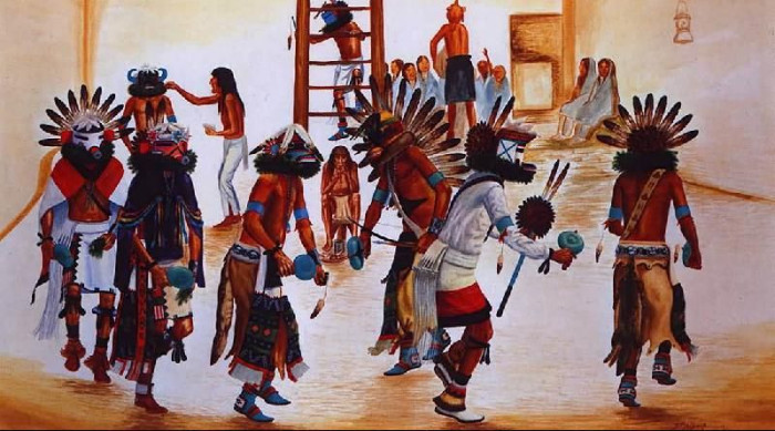
'콘디안 문화' 게시판에서 그리고 앞선 글들에서 밝혔지만, 호피(Hopi) 인디안들의 '캐지나(Kachina)' 전통은 우리 민족의 풍물놀이 '쾌지나 칭칭나네'의 지신밟기와 유사하게 집집마다 방문하며 그들의 풍물을 치며 춤을 춘다. 특히 호피 인디안들의 캐지나는 얼굴에 탈을 쓰고 풍물놀이를 한다는데서 탈춤풍물이라 할 수 있다. 남사당패 놀이에서 탈과 같은 꼭두각시놀이와 유사한데가 있으며, 호피인디안들은 캐지나를 마치면 꼭두각시를 만들어 어린이들에게 선물로 주는 풍속이 있다.
호피(Hopi) 인디안들의 '캐지나(Kachina)' 풍물놀이하는 모습.
사람이 죽어 동물로 환생하는 것을 모양이 이동한다는 이른바 화신(Shapeshifters)을 의미한다. 화신에는 몇 가지 종류가 있다. 그중 하나는 사람이 다른 동물로 또는 동물이 사람으로 전환하는 단순 화신이 있고 또 하나는 사람 위에 동물이 옷을 입는 것처럼 껍질만 쓰는 것(fold over)을 의미한다. 이것이 '탈' 문화의 기원이 되었을 것으로 보인다. 그러니까 속은 그대로 본래의 형체를 가지고 있는 것을 의미한다.
A second style is what can be called the 'fold over'. In this transformation, the subject's new flesh forms overtop of their original. In a sense, it is almost as if they are wearing a body over another, and their old form is underneath.
이런 경우 언제든지 안에 감추어진 '마각'을 드러내는 것으로 믿어졌다. 그런데 겹친 몸의 화신인 경우 영화에서 자주 보여주는 것처럼 죽으면 그 본색의 속 몸이 드러나는 경우로 받아들여졌다.
*Navajo City, New Mexico
울산 반구대의 선사시대 코리안들의 신화체계는 복잡한 이와같은 화신 신앙으로 고래를 대했음이 분명하다. 까마귀(태양새)와 고래 그리고 고래잡이 세 가지 형태의 화신의 탈 문화에 대하여서는 앞선 글에서 밝혔다.
그런데 이러한 화신은 살아서 변신하는 '둔갑'보다는 죽어서 환생하는 환생사상을 가졌다. 그래서 살아 있는 사람에게는 죽은 사람의 귀신이 동물의 형태로 나타난다(Ghosts sometimes appear in animal form.)고 믿은 것이다. 고래가 조상이라고 생각하거나 상어가 조상이라고 생각하고 있는 오늘날의 원시 고래잡이들의 신앙에 대하여서 앞선 글에서 다루었다.
나중에 바다생활보다 육지생활이 강조된 곳에서는 곰이나 여우가 화신의 대상이 되었다. 일본 신도의 경우 여우가 신도의 카미인 이나리(Inari)로 화신될 수 있다고 믿었다.
화신의 경우 스킨워커(Skin-walker)의 경우는 그저 다른 동물의 가죽을 뒤집어 쓰고 걸어간다는 의미로 메타모르프, 미믹, 데리안쓰로프 등의 형태가 있다. 스킨워커의 경우 나바호족의 이이나알들루쉬이(yee naaldlooshii )는 그 뜻이 "사방으로 사라지는 둔갑 with it, he goes on all fours)"이라는 의미가 있다. 카요티, 늑대, 부엉이, 여우, 까마귀 등으로 변하여 사라지는 것이다.
나바호족들의 전승에는 스킨워커들이 다른 사람의 몸이나 그 피부 전체를 훔칠 수 있는 능력이 있다고 믿었다. 나바호 사람들은 만일 당신이 스킨워커를 만나 눈을 감으면 그들은 당신 몸 안으로 들어와버린다고 생각했다. 스킨워커들은 빛을 피하는데 그들이 사람의 몸으로 둔갑해 있을 때 그들의 눈은 동물 눈처럼 이글거린다고 생각했다. 그러나 동물로 변해 있을 때는 그 눈은 사람의 눈처럼 되어 이글거림이 없다고 생각했다.
Some Navajo also believe that skinwalkers have the ability to steal the "skin" or body of a person. The Navajo believe that if you lock eyes with a skinwalker they can absorb themselves into your body. It is also said that skinwalkers avoid the light and that their eyes glow like an animal's when in human form and when in animal form their eyes do not glow as an animal's would.
스와쯔네거가 나오는 영화 <터미네이터>의 첫 장면에서 우주의 괴물과 같은 로보트가 벌거벗은 사람의 몸으로 웅크리고 나타난 모습으로 묘사된 것은 나바호 인디안들의 스킨워커의 '나체성'에서 모방한 것이다. 스킨워커들이 사람으로 변형할 때는 주로 나체 사람으로 둔갑된다.
스킨워커들은 동물 둔갑이 아니면 사람으로 둔갑할 대 주로 나체로 묘사된다. 어떤 나바하 인디안들은 동물의 둔갑 형태로 묘사한다. 둔갑하는 껍질은 마녀들의 주문으로 겉옷을 입는 것과 같이 '탈(mask)'에 불과하다는 것으로 받아들였다.
A skinwalker is usually described as naked, except for an animal skin. Some Navajos describe them as a mutated version of the animal in question. The skin may just be a mask, like those which are the only garment worn in the witches' song.
처용탈춤의 원형이 이와같은 고래와 까마귀에 연관한 고래잡이들의 화신과 둔갑에 연결되어 있었을 것이라는 것이 필자의 분석이다. 고조선의 곰과 웅녀의 화신을 비롯하여 적어도 사슴이나 고래는 백제와 신라에 전해진 왕족들의 오래된 화신 신화를 배경하고 있었을 것으로 생각된다.
동물 겉모양이 스킨워커들의 모습일 수 있기 때문에 나바호족 인디안들에게는 곰, 카요티, 늑대, 쿠거 등의 동물들을 엄격히 터부시했다. 양의 가죽이나 사슴 가죽은 나바호족들에게 별로 사용되지 않았는데 사슴가죽의 경우 종교적 의식에 사용했다.
Because animal skins are used primarily by skinwalkers, the pelt of animals such as bears, coyotes, wolves, and cougars are strictly tabooed. Sheepskin and buckskin are probably two of the few hides used by Navajos; the latter is used only for ceremonial purposes.
나바호 인디안들은 자주 그들이 스킨워커들과 만났다고 말한다. 다만 그들은 나바호족이 아닌 사람들에게는 그러한 이야기를 하기를 피한다. 때로는 스킨워커들이 집의 벽을 부수고 들어오기도 하고 안의 사람들을 공격하기도 하고 밖에서 벽을 치기도 하고 창문을 두드리거나 지붕에 올라가기도 한다는 것이다.
Often, Navajos will tell of their encounter with a skinwalker, though there is a lot of hesitancy to reveal the story to non-Navajos, or (understandably) to talk of such frightening things at night. Sometimes the skinwalker will try to break into the house and attack the people inside, and will often bang on the walls of the house, knock on the windows, and climb onto the roofs.
어떤 경우 이상한 동물처럼 생긴 사람이 창문 밖에 서 있는 것이 보이기도 한다. 또 다른 경우 스킨워커는 차량을 공격하기도 하고 차 사고를 유발시키기도 한다는 것이다. 그러나 스킨웤커는 워낙 빠르고 민첩하여 잡을 수가 없다는 것이다.
Sometimes, a strange, animal-like figure is seen standing outside the window, peering in. Other times, a skinwalker may attack a vehicle and cause a car accident. The skinwalkers are described as being fast, agile, and impossible to catch.
나는 나바호 인디안들의 스킨워커 전승이 우리 민족의 도깨비 문화와 일치한다고 생각한다. 전
Legend has it, skinwalkers can have the power to read human thoughts. They also possess the ability to make any human or animal noise they choose. A skinwalker may use the voice of a relative or the cry of an infant to lure victims out of the safety of their homes.
스킨워커들은 공포를 주기 위하여 주문을 사용하는데 사람의 뼈로 만든 구슬을 총알로 사용할 수도 있는데 그 총알을 맞은 사람은 그 피부 아래에서 그 뼈 총알이 가루가 되어 전신을 마시비시고 심장마비가 된다는 것이다.
이러한 나바호족의 스킨워커의 유래는 백인들의 고문을 피하여 공포 속에서 도망친 것에서 비롯했다는 설이 있다. 또 다른 유래는 옛날 가난한 사람들이 사는 곳에서 시작된 것으로 밤에는 종교의식 때 입는 옷을 입고 집집마다 방문하던 것에서 시작되었다는 것이다. 또 하나의 유래는 라코타 인디안들의 전설로서 인디안 도술사(medicine man)가 늑대처럼 옷을 입고 바이슨을 사냥한 것에서 비롯되었다는 것이다.
아메리카 인디안들의 토템 폴에서 짐승과 사람 그리고 새가 등장하는 기둥은 단군신화의 신단수 나무기둥에 곰과 사람 그리고 태양새인 삼족오가 함께 새겨진 것으로 표현될 수 있다. 나바호족의 신화적인 이이나알들루쉬이 도깨비 둔갑술은 코리안들의 신화적인 토템의 배경을 설명해주는 전승의 한 잔흔으로 볼 수 있다.
*곰 가죽을 쓴 인디안 http://www.nativeonline.com/image.html
밤중에 도깨비와 싸웠는데 이튿날 아침에 보니 비자루 몽뎅이였더라는 우리의 오랜 도깨비 이야기는 나바호 인디안들에게 '이이나알들루쉬이(yee naaldlooshii )'로 전해져 온 것이다. 이러한 화신 신화적인 둔갑 형태의 원시 선사시대 스타일은 신선이 되는 비익조 전설이나 신라의 왕이 죽으면 동해구에 산골하여 동해의 신룡(고래)가 된다는 환생사상과 함께 존재했던 것으로 볼 수 있다. (11/06/09 오두)
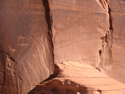
*나바호 인디안들의 암각화. 음양 태극마크가 있다. 울산 반구대 인근 천전리 암각화처럼 뱀 모양의 지그재그 암각화가 유사하다.
*나바호 암각화에서 고구려 고분 천정 문양이 있다?
*고구려 고분 벽화 천정 부분
*나바호 인디안들의 '마름모 문양'의 연속은 천전리 암각화의 마름모 문양의 연속을 닮아 있다. http://www.flickr.com/photos/chriscorrigan/392647956/
*나바호 인디안들의 추상적인 암각화 http://www.flickr.com/photos/strixaluco/251664625/
*아래는 임시저장
- 임시보관용 -
지구온난화로 남·북극의 빙하들이 예상보다 훨씬 빨리 녹아없어지면서 금세기 말이면 해수면이 현재보다 6m 이상 높아질 것이며 이에 따라 마이애미와 방콕, 몰디브의 섬들이 물에 잠겨 사라질 것이라고 24일 발매된 미 과학잡지 '사이언스'가 기후변화를 연구하는 과학자들의 연구 결과를 인용해 경고했다 3/24뉴스 AP 로이터
미 애리조나대학의 기후학자 조나선 오버펙은 지구온난화 추세가 지금과 같은 속도로 지속될 경우 지구 기온이 금세기 말 현재보다 섭씨 2.3도 높아져 13만년래 최고를 기록할 것이라고 밝혔다. 이럴 경우 그린랜드와 남극의 빙하들이 녹아내릴 것이며 해수면은 현재보다 최소 1미터에서 최고 6m나 높아질 것이라고 오버펙은 덧붙였다.
Beringia 와 요나구니 유적
http://www.history.emory.edu/RAVINA/Multimedia_textbook/Maps/Ice_age_map.html
동해를 Sea of Japan으로 표기하고 있고 중국쪽에서 오는듯한 인상주게 했다 source: Collcutt, Jansen and Kumakura, Cultural Atlas of Japan, 33.
the first Wisconsin stage of the ice age (70,000 - 50,000 BC) or the second stage (50,000 - 40,000 BC). Sea levels fell as much as 500 feet due to the impounding of water by the forming ice. Conversely, when the ice melted, the sea levels rose and Beringia submerged. the first Wisconsin stage of the ice age (70,000 - 50,000 BC) or the second stage (50,000 - 40,000 BC). Sea levels fell as much as 500 feet due to the impounding of water by the forming ice. Conversely, when the ice melted, the sea levels rose and Beringia submerged.
Humans are believed to have crossed into the Americas before the end of the last ice age, when a natural land bridge called Beringia linked present-day Siberia and Alaska. During the coldest part of the ice age, about 23,000 to 19,000 years ago, vast glaciers blanketed much of the northern hemisphere, making travel south toward what is now the continental United States virtually impossible. By about 14,000 years ago, as the climate warmed, a passable route opened along the Pacific Coast. Then, about 2,500 years later, an ice-free corridor opened in the contintental interior as the great ice sheets retreated. Some scientists believe both routes were used by early migrating peoples.
The structure off the coast of Yonaguni has been hailed as "the world's oldest building" (Barot, 1998), taking the form of a "stone ziggurat" dating back to 8000 B.C. (Barot, 1998).
요나구니 섬의 바다 밑 도시
오키나와현 与那国島
플라톤의 아틀란티스 빙하문제
120m by 40m 12,000년 전에 생긴 것 최후의 빙하시대 가장 오래된 인류 유적? Kenny Ehman in his article (appeared in DIVER Magazine UK - July 1999) asked him if he believes that there might be a connection to the underwater sites that he studied in the Canary Islands and at Bimini Island, this was his reply: "There was a race of humans called the Cro-Magnons. Some of the bones of Cro-Magnons have been found in the Canary Islands, where they are known locally as the Guanches. The average height of these humans was 2m. They had blond hair and blue eyes, and were extremely artistic. The theory is that they may have come from a lost continent - maybe Atlantis," explains Mayol excitedly as we stand on one of Yonaguni's tall cliffs.
요나구니 육지로 연결 "There was a race of humans called the Cro-Magnons. Some of the bones of Cro-Magnons have been found in the Canary Islands, where they are known locally as the Guanches. The average height of these humans was 2m. They had blond hair and blue eyes, and were extremely artistic. The theory is that they may have come from a lost continent - maybe Atlantis," explains Mayol excitedly as we stand on one of Yonaguni's tall cliffs.
Yonaguni is a small island south-west of Okinawa in the Japanese archipelago. In 1988, scuba divers led by Kihachiro Aratake discovered an enormous stone structure on the seabed off the coast of Yonaguni.
The structure lay more than 75 feet below the surface.
Investigation showed it was 600 feet long, 450 feet wide and 90 feet high.
The locals decided it was a natural formation.
Ten years later, the experts weren't so sure. The first geologist to investigate the site was Professor Masaki Kimura of Ryuku University on Okinawa. In April 1998, he discovered a structure divided into five distinct layers and decided it had to be manmade.
It is easy to see why. Underwater photographs and video footage reveal a stepped, ziggurat-like monument of extraordinary proportions.
Each step is about 3 feet high with clean edges and sharp angles.
There is also an archway and two parallel monoliths among other intriguing features like drainage channels.
Robert Schoch, the American geologist who re-dated the sphinx, dived to examine the Yonaguni Monument and later commented that while natural water erosion and rock splitting might possibly produce a structure of this type, he had never seen anything quite like it before. Professor Kimura was even more forthcoming. 파도가 만들어
부분적으로 인간이 손댔다.
Geological dating places the site above water no later than 8000 BC. (The actual time-span is somewhere between 8000 and 10,000 BC.)
Orthodox prehistory claims the most advanced culture in Japan at the time was small groups of hunter-gatherers. 일본인들은 수렵시대
As Professor Kimura points out, there is no way they could have built or even modified the Yonaguni Monument. He believes for something of this size some sort of machinery must have been involved. 기계를 동원해야 만든다.
Answer
Beringia
http://www.hydrogentrain.com/bering_straight_trail.htm
The Bering Straight migration theory suggests that humans began crossing the Bering Straight as early as 15,000 B.C. The area of the Bering Land Bridge, called by some scholars “Beringia” is thought to have been a 500-mile wide swath of land covered with tundra-like vegetation used by both humans and animals to cross into the North American arctic regions and beyond. This swath of land is thought to have been created 20,000 to 25,000 years ago, near the end of the Pleistocene (Ice Ages). Continental glaciers forming in the northern hemisphere locked up so much water that the level of the oceans are thought to have dropped more than 300 feet lower than present levels.

Techichis: It is known that the Toltecs, a wandering people of Central America, settled in Mexico approximately 11,000 years ago. The Toltecs had little dogs with long hair, known as techichis. Their likeness can be found on many engraved stones of that period.
Mexican naked dog: It is believed that the Mexican naked dog had its origins in China, and was introduced with wandering tribes crossing the Bering Straight to settle on the North American Continent.
When the Toltecs were attacked and defeated by the Aztec people in the 14th century, these little dogs became the pets of the Aztec aristocracy and were the object of real veneration. It is believed that the Aztec people appreciated this small breed for companionship, and also for culinary reasons....
As the dating for human migration across Bering Strait is pushed further and further back in time, there is a tendency to forget that such migration was not a single incident, but rather a continuing one. Until modem hostilities developed between the former Soviet Union and the United States, communication across the Strait was an ongoing process; it did not require a land bridge.
Similar cultural developments on both sides of Bering Strait suggest that the people had been moving back and forth across it for thousands of years. Indeed, human migration and interaction between Chukotka and Alaska probably have been more or less continuous ever since the straight was most recently formed, some 14,000 years ago. (Burch, Jr. 1988: 227) 양쪽 동시 발달
The Red Record begins with the Lenni-Lenape story of the Creation - with Adam and Eve and the Snake of Eden - each with a Native name. Throughout time, the snake has been the Lenni-Lenape symbol for the enemy. The story of man's struggle continues through the Great Flood, and the re-settling of the land after the waters receded. At the time of the re-settling, there came a common understanding shared by all the people that a great body of water lay to their east. It was their destiny to reach that body of water, and so their migration began.
The Red Record estimates that the migration began 1600 years Before Christ. The people set out from their ancestral home located near the border between present day China, Mongolia and Russia. on their journey eastward, settlements, villages and towns of the various inhabitants along their path were encountered. Some were avoided, and some allowed safe and peaceful passage, but there battles and wars to be fought, especially among the great dynasties of China.
The Lenni-Lenape reached the Bering Straight, which was primarily a land bridge with a small strip of swift and treacherous water between them and the shores of present day Alaska. Realizing that they could not cross the water safely, they camped along the shore waiting for the waters to freeze over. When the freeze came, some 10,000 people made the crossing into the North American Continent.
As they traveled inland, they encountered other Natives already living in the area. The main body of the migration divided, with some bearing south into the area of British Columbia and the Pacific Northwest, and others continuing deeper into Canada. Their passage through this territory continues to be evidenced today by marked differences in the appearance and customs of the interior Eskimo, and the coastal Eskimo/Inuit.
The "Red Record" (The Wallum Olum) is not new or a recently discovered piece of ancient history. It was given to the white man in 1820, when its last caretaker presented it to a Dr. Ward, a Moravian missionary and physician who had lived among the Lenni-Lenape for a number of years. Dr. Ward had saved the life of the village historian and, as a show of appreciation, the Red Record was given with the statement, "This is like our Bible".
Their language lay at the root of the Algonquian-speaking people; the most widespread language group in pre-Columbian North America. They were the founding fathers of: The Mohicans; the Nanticokes; the Shawnee; the Ojibwa; The Cree; the Powhatan; the Abenaki; the Massachusetts; the Blackfoot; the Cheyenne; the Munsees; the Yuroks; the Wiyots; the Algonkins; the Montagnais; the Arapahoe; the Menominee; the Potowatomi; the Ottowa; the Sauk; the Fox; the Nipmuc; the Narraganset; the Pequot; the Wampanoag; the Montauk; the Illinois; the Conoy, and surely many others not discovered, all of whom tell the same story of creation and migration, all of whom refer to the Lenni-Lenape as "Grandfather", and all of whom defer to the Lenni-Lenape as their ancestral elders. The last entry into the Red Record was in 1620. Linda Poolaw, the Grand Chief of the Delaware Nation Grand Council of North America in Oklahoma.
The Red Record is the oldest written record of a Native North American people, and spans almost 100 generations. It is not a large book, and is fast reading well worth your time. It may be in the history or research section of your library, or any store that carries Native American books can order it for you. Complete information is: "The Red Record: The Wallam Olum", by David McCutchen, (c) 1993; Avery Publishing Group, Inc., Garden City Park, New York; $14.95 For More on the Red Record see: www.meyna.com/lenape.html
It has long been accepted among scholars that proto-Athapaskan speaking people were the last Native Americans, excluding Polar peoples, to cross into the Americas. In this paper, it will be suggested that this migration took place within the time span covered by trans-Pacific contact studies, and a major Asian technical complex, the most advanced form of archery, among other cultural aspects was brought with them as far south as northern Mexico.
Florida's first people arrived more than 12,000 years ago crossing the Bering Strait on foot, in search of food. Evidence that Manatee County's first inhabitants depended on the resources of the Manatee River can be found in the burial, midden, and temple mounds located along the river's banks. For centuries, these Indian tribes were left alone to enjoy what is today, Manatee County.
In a field along the trail, Curly Bear Wagner, a Blackfoot cultural leader, holds a rattle made of wood, bear hide, feathers, buffalo fur and turtle shell that he uses in ceremonial dances. He says his great-grandfather walked the trail from Montana to Mexico.
"Imagine a mountain ridge that snakes like a knobbly spine all the way from the frozen Canadian Arctic down to the deserts of Mexico.
'The Backbone of the World,' the Blackfoot Indians called what we know as the Rocky Mountains and the Continental Divide. Now imagine a footpath that runs along the base of the mountains following the 'shoreline' between the mountains and the plains — twisting through stream gullies, unraveling over low ridges and around buttes running on for 2,000 to 3,000 miles." So writes Peter Stark in July's Smithsonian Magazine. Fragmentary evidence indicates that such a footpath existed, and it is called the Old North Trail.
For 10,000 years inhabitants of North America used the Old North Trail, first on foot, then with dogs pulling cargo-laden travois, and finally with horses. Stark recreates part of the journey reflecting on what it might have been like to be an ancient traveler carrying trade goods — such as obsidian for spearheads and seashells from the coast — or visiting relatives, setting off on sacred missions, seeking a mate or just satisfying a curiosity about new lands.
There is intriguing evidence that early travelers used a network of footpaths that crisscrossed North America and traveled thousands of miles long before Europeans arrived, even before the last ice age ended. As more physical evidence is uncovered along the Old North Trail, the stories and oral legends of the Blackfoot Indians take on new meaning. The possibility exists that the humans who crossed from Asia on the Bering Land Bridge about 15,000 years ago and populated North America might have found an ice-free corridor along the eastern slope of the Rockies, to the area where the Trail now runs. That means the Old North Trail may have carried the weight of one of the most significant human migrations of all time.
September 2004--- A Stunning Find Deep in a Utah Canyon
The half-buried stone-and-mortar houses, granary caches, and painted colorful trapezoidal figures on canyon walls found deep in the heart of Utah were home to an ancient civilization that dates from 300 years before the birth of Christ, reports The Associated Press. (기원전 300년 스페인)
The ruins of the so-called Fremont people--named for a Spanish explorer who never even met them--are a treasure trove for archaeologists because they are virtually untouched by looters. The artifacts could reveal secrets about the original Paleo-Indians, America's earliest inhabitants who are thought to have arrived in North America by way of the Bering Strait some 10,000 years ago.
They lived on this site in what is now modern-day Utah over a span of centuries that ended about 750 years ago. "It's like finding a van Gogh in your grandmother's attic," Utah state archaeologist Kevin Jones told AP. Unlike the nearby Anasazi people who were farmers, the Fremont were known for their creativity. In addition to the farming and hunting skills they needed to survive, the Fremont had a distinctive style of basket weaving and made animal-claw moccasins. Even their everyday tools and pottery were quite different from the Anasazi.
The two cultures do have one thing in common:
They both packed up and left at the same time around 1250 A.D., and to this day it's not known why they fled or what became of them. The Utah canyon in which the ruins were found were recently turned over to archaeologists by a rancher who owned the land and kept the site a secret in an attempt to preserve it. Historians think this space, which was likely home to some 250 households, could have been the Fremont's last settlement. They will look for clues as to why they were driven out of Utah.
Here are some of the recent finds in the Fremont ruins: (아래쪽 자료첨부)
--Paddle-like wood shovel.
--Rare bundle of arrow shafts, found wedged in a canyon wall.
--Perfectly preserved beehive-shaped granary with a cap stone, still a third full with piles of parched wild grass seed and corn.
--Pair of human remains from surrounding federal land.
Call it lost in plain sight. Look what a team of British and American explorers found in the jungles of Peru--that had been lost for centuries.
Call it lost in plain sight. A team of British and American explorers has located in the jungles of Peru an Incan city that has been lost for centuries, reports Reuters. Amazingly, it is within sight of a key religious center at Machu Picchu.
Briton Hugh Thomson and American Gary Zeigler knew Llactapata was there. Somewhere. It was first mentioned in 1912 by explorer Hiram Bingham, the discoverer of Machu Picchu. But since his description of the location was very vague, the ruins of Llactapata were never found by anyone else.
Fast forward 90 years. Using infrared aerial photography to penetrate the dense forest canopy, Thomson and Zeigler were able to pinpoint the location of the lost city. The high-tech help ended there, though. They still had to climb 9,000 feet up the side of a mountain using machetes to hack their way through the jungle.
It was worth it. When they finally arrived in Llactapata, they found stone buildings, including a solar temple and houses covering several square miles. Here's the most interesting part: The buildings are located in the same alignment with the Pleiades star cluster and the June solstice sunrise as Machu Picchu, which was a sacred center.
"This is a very important discovery. It is very close to Machu Picchu and aligned with it. This adds significantly to our knowledge about Machu Picchu," Thomson told Reuters. "Llactapata adds to its significance."
황도 12궁 중의 하나인 황소자리 금우궁(金牛宮)의 산개성단. 태양계에서 약 400광년 떨어져 있으며 목록번호는 M45이다. 상당량의 밝은 성운물질과 수백 개의 별들로 이루어져 있으며, 이 별들 중 6~7개는 육안으로도 보이기 때문에 여러 문화권의 신화와 문학에서 자주 등장한다. 그리스 신화에서는 아틀라스와 플레이오네 사이에서 태어난 일곱 자매(알키오네·마이아·엘렉트라·메로페·타이게테·켈라이노·스테로테페로, 이들의 이름은 각각 별의 이름으로 붙여졌음)가 별이 된 것이라고 한다. 고대로부터 북반구에서는 봄철 새벽에 태양이 떠오를 무렵 이 성단이 떠오르면 항해와 농사를 시작하는 계절임을 나타내고, 가을 아침에 서쪽으로 지면 계절이 끝나는 것을 나타내는 것으로 여겼다. 남아메리카의 몇몇 인디언 부족들은 플레이아데스 성단을 부르는 이름과 년[年]을 나타내는 이름을 같은 것으로 불렀다. 갈릴레오는 이 성단을 망원경으로 처음 관측해 40개 이상의 별들을 발견했다. 1885년 폴과 프로스퍼 헨리가 최초로 플레이아데스 성단의 사진을 찍었다. (데빌스 타워 7처녀와 그리이스 신화 "플레이아데스는 일곱 자매로, 신이 되어 플레이아데스 성단이라 불리는 별자리가 되었다. 그녀들은 거인 아틀라스와 플레이오네의 딸들이다(☞계보 25). 그녀들의 이름은 타이게테, 엘렉트라, 알키오네, 아스테로페, 켈라이노, 마이아, 메로페 등이다) 플레이아데스는 단 한 명만 빼고 모두 신들과 결혼했다. 단 한 명 메로페만 인간인 시시포스와 결혼했으며 그녀는 이를 수치스럽게 여겼다. 그녀의 별이 성단 중에 가장 덜 밝은 것도 그 때문이라 한다
DNA http://cita.chattanooga.org/mtdna.html More recently, DNA-based research (http://cita.chattanooga.org/mtdna.html) has suggested they came from Melanesia and traveled up to North Asia and across the Bering land bridge. Polynesians in turn are thought to have originated from China. 해변따라?
베링해협 외에 폴리네시안 Americas 6,000 to 12,000 years ago.
2만년-4만년 전에 아메린드들 들어왔다. The mtDNA analyses are showing that the ancestors of the Amerinds, who comprise most Native Americans, entered the Americans in a single migratory wave 20,000 to 40,000 years ago, Dr. Wallace and his Emory colleagues ... reported last year. This puts humans in the Americas long before a fluted stone-spear point--the oldest American tool ever found--was dropped by a prehistoric dweller near Clovis, N.M., 11,000 years ago.
The researchers also found that ancestors of the Navajo, Apache and other members of a Native American group, known collectively as the Na-Dene, are latecomers; they entered the continent in a second migration a mere 5,000 to 10,000 years ago, the research indicates.
베링해협이 약하다 native Siberians lack one peculiar mutation that appeared in the Amerinds 6,000 to 10,000 years ago. This raises the question of where, if not from Siberia, this mtDNA originated.
폴리네시안이 강하다 It turns out, Dr. Wallace says, that this particular mutation pattern is also found in aboriginal populations in Southeast Asia and in the islands of Melanesia and Polynesia.
Then some 6,000 to 12,000 years ago these ancient mariners made it to the Americas. "I don't know how they came," Dr. Wallace says. "They either came across the Pacific to Central and South America or they went up the east coast of Asia and across the northern Pacific to Alaska and Canada," he says. He already is examining mtDNA samples from natives of the Kamchatka Peninsula north of Japan to see if there is any mtDNA trace of these ancient sailors.
http://www.marcopolovoyages.com/LibCongressPapers/GunnarThompson3.html Along the West Coast of North America, Mercator honored the explorations of Marco Polo. His map uses the place names that Marco Polo gave to regions of America’s West Coast in the 13th century. These include: Bergi, Anian, Quivira, and Toloman.
One thing archaeologists know for sure: There are more lost Incan cities just waiting to be found. After the Spanish Conquistadors captured and executed the last Incan leader, Tupac Amaru, in 1572, the Incans deserted their cities and towns and beat a hasty retreat. Reuters notes that while some of the cities have been rediscovered, many more are believed to lie hidden in the dense jungle. The only way they will ever be found is with new technology or dumb luck. And machetes.
An ancient Teotihuacan settlement that is about 2,000 years old was recently unearthed in Mexico. Artifacts--some with an unspeakably gruesome purpose--were found.
The place: Mexico City, about 30 miles from the pyramids.
The find: An ancient Teotihuacan settlement that is about 2,000 years old. Artifacts--some with an unspeakably gruesome purpose--were found.
The importance: The Teotihuacan culture influenced the area around what is now Mexico City far earlier than historians previously thought.
The recent discovery of a Teotihuacan settlement on a hill just behind the Chapultepec Castle in Mexico City includes building structures, tools, and religious artifacts. But even with this tangible find that tells stories of everyday life, the ancient city of Teotihuacan, which lies north of modern Mexico City and flourished during the time of Christ, is still a mystery--just as it was to the Aztecs who first stumbled on it in the 1300s.
In its day, Teotihuacan was one of the world's largest cities with some 150,000 residents, whose culture had a far-reaching impact on art and architecture as far away as the Yucatan peninsula. But by the time the Aztecs arrived, Teotihuacan had long been abandoned and left crumbling. What happened? No one knows. It's a mystery that has endured for centuries.
The Teotihuacan artifacts that have just been found could rewrite the history books, pushing back the date of Mexico City's founding to the period of 300 to 600. AP reports that the relics located in the 20-square-yard excavation include six pairs of ceramic urns of Teotihuacan style that may have been used to hold the remains of children sacrificed to the god of rain. Other relics include ceramic domestic tools, a bone needle, and a figurine that was most likely used in religious rituals.
Archaeologists have also uncovered the remnants of a stone wall and floor that both date from the same period.
"This is a very important discovery, one that is just beginning," Maria de la Luz Moreno Cabrera, the archaeologist leading the investigation, told AP. "It is very exciting to find such a site...it helps to show the real historical importance of this area."
What are the origins of human civilization?
In western civilization, traditional theories of origin until the mid-19th century were based on interpretations of scripture, which suggest civilization, as well as all of creation, originated in what is now the Middle East some 5,000 years ago. Modern scholarship as it has developed over time has been rather zealous in its defense of this view. Mr. Cogan would have us believe an entirely different scenario. According to Mr. Cogan, complex human civilizations first emerged at the tail end of the last Ice Age 40,000 years ago in what is now the Sahara in Africa. Ice sheets encroaching the northern latitudes for some 160,000 years reached glacial maximum around 18,000B.C. After glacial maximum the cooling-warming cycle of the Earth reversed and slowly the ice sheets began to recede. This melting cased the Sahara to become less fertile and increasingly arid, which would continue until it became the desert of modern times. This spurred these ancient humans to confront the problem of overpopulation, stimulating creativity and the eventual making complex maps, construction of seafaring vessels capable of crossing oceans. Slowly humans began to migrate east to China and west to South America. By around 10,500 BC, humans had settlements scattered over all the inhabitable parts of the globe when quite suddenly this First Civilization came to an end.
Responsible for the end to the 1st complex human civilization was an asteroid estimated to be six and a half miles wide travelling 40,000 miles per hour, struck the Earth in the North Atlantic. This impact fractured the earth’s crust causing a large percentage of the oceans water to immediately evaporate when molten lava make contact with the water. Huge amounts of earthen debris were thrown so high into the upper atmosphere it would take decades to fall back to the earth. The impact also triggered tremendous volcanic activity following the impact of the asteroid. This unleashed immense amounts of green house gasses into the atmosphere and accelerated the disintegration of the glacial ice sheets which melted in 4,000 years (instead of the 160,000years it would normally take) causing ocean levels to rise 400 feet. Submerged were many of the cities of the first civilization, which were located near coasts. on land, the asteroid killed 90 percent of all living things, particularly large animals. Humans as a species narrowly survived this catastrophe and the first attempt at complex civilization was put asunder. For 5,000 years human activity ceased to exist. Then, quite suddenly around 4,000 B.C., four separate parts of the world (Mesopotamia, Egypt, and Indus Valley and Mayan) civilizations spring up and the march of history as we know it begins.
4대문명은 2차 대문명시대
레드 리코드 위에서 언급한 자료 판소리=virch bark에 새긴 기록의 노래 THE LENNI-LENAPE AND THE "RED RECORD"
The Red Record has passed through many hands, but most did not even examine the carved and painted prayer sticks made of bark and wood. Finally, it fell into scholarly hands and the inquiry into its meaning began. As the words and symbols of the Red Record were matched to each other by anthropologists, archealogists and historians, the impact of these writings began to emerge. Each time understanding was near, the writings were pushed aside. There were a number of reasons for this, as there are for all ancient writings as they are discovered. Firstly, translating and understanding the Red Record would have destroyed the European position that they had taken this land because it was an uncivilized country inhabited by heathen savages. Secondly, it was believed that these heathen savages did not have the mental capacity to maintain a written history of their people. Thirdly, so little was known of the world described by the Red Record that it was passed off as more Native myths and legends. In spite of this, the inborn curiosity of the intellectual and learned people of history were fascinated by this mystery. With the aerial photographs of Russia, China, Japan and Africa of World War II, and the later, sophisticated photographs and maps from satellites, connections were made with the Red Record which set about the first serious and scientific examination of its meaning. After more than 20 years of work and study, a translation was completed. In 1976, David McCutchen, a graduate of the University of California at Santa Barbara and the California Institute of the Arts, was hired to research the history of the Delaware Nation. It should be pointed out that the tribal name "Lenni-Lenape" meant the "Original People". In 1610, Captain Samuel Argall sailed up the Lenape River, and named both the river, and the people living on its banks, the "Delaware" in honor of his patron, Lord De La Warr. From that time on, these people were referred to by outsiders and Europeans as the "Delaware". In his work, McCutchen came upon The Red Record, the history of its translation, some of the original wooden prayer sticks, and the original words which described the meanings of the carvings. He completed his study as far as he could, and then proceeded to go to the source. He took the results of his research, photographs of the original prayer sticks, and all materials the curators would allow, to Linda Poolaw, the Grand Chief of the Delaware Nation Grand Council of North America in Oklahoma. With Chief Poolaw's assistance, McCutchen was able to fill in the blanks, answer remaining questions and complete the final translation of The Red Record. In 1980, the tribal descendents of the Lenni-Lenape passed a resolution endorsing McCutchen's recreation of the entire Red Record as an accurate re-telling of the history of their people. As we begin the journey of the Lenni-Lenape, it is important to remember the time frames covered. They did not fly the friendly skies, nor did they take the bus and leave the driving to someone else. THEY WALKED!! The Red Record begins with the Lenni-Lenape story of the Creation - with Adam and Eve and the Snake of Eden - each with a Native name. Throughout time, the snake has been the Lenni-Lenape symbol for the enemy. The story of man's struggle continues through the Great Flood, and the re-settling of the land after the waters receded. At the time of the re-settling, there came a common understanding shared by all the people that a great body of water lay to their east. It was their destiny to reach that body of water, and so their migration began. The first scholar to investigate the Red Record estimates that the migration began 1600 years Before Christ. The people set out from their ancestral home located near the border between present day China, Mongolia and Russia. on their journey eastward, settlements, villages and towns of the various inhabitants along their path were encountered. Some were avoided, and some allowed safe and peaceful passage, but there battles and wars to be fought, especially among the great dynasties of China. The Lenni-Lenape reached the Bering Straight, which was primarily a land bridge with a small strip of swift and treacherous water between them and the shores of present day Alaska. Realizing that they could not cross the water safely, they camped along the shore waiting for the waters to freeze over. When the freeze came, some 10,000 people made the crossing into the North American Continent. As they traveled inland, they encountered other Natives already living in the area. The main body of the migration divided, with some bearing south into the area of British Columbia and the Pacific Northwest, and others continuing deeper into Canada. Their passage through this territory continues to be evidenced today by marked differences in the appearance and customs of the interior Eskimo, and the coastal Eskimo/Inuit. During their travels, the Lenni-Lenape encountered many Natives already living and working on the land. When they reached fertile areas where the fishing, hunting and farming were good, they would settle for a time, learn the hunting and farming techniques of the people already there, and replenish their strength and their food supplies. During these times of peace and prosperity, their numbers would increase. Each time the main body of the migration would continue their search for the great water in the east, various groups would remain behind because they had become attached to the area and its life. Others would continue southward, and eventually ended up at the mesas and pueblos of the Anasazi to became their peaceful neighbors. This would account for the oriental features found in the remains of some ancient Anasazi as previously discussed. The groups who settled in various parts of the country eventually took other names more descriptive of their lifestyles, or were given different names by neighboring tribes. The physical environment, and the attitude of the existing inhabitants, greatly influenced the crossing of this continent. Great droughts forced them to move quickly, and great wars stopped them altogether. Two major conflicts are worthy of mention: one in the Pacific Northwest and one in the Mississippi River Valley. The tribes of the Pacific Northwest, at this time in history, were extremely fierce and war-like, and did not look kindly upon the newcomers. They practiced sorcery and black magic, which were hated by the Lenni-Lenape. A great war broke out and the Lenni-Lenape, who were great warriors, prevailed. The Mississippi River Valley was lush and fertile, and was looked upon by the Lenni-Lenape as a good place to establish a permanent settlement. They followed it downstream to its junction with the Missouri River where they came face to face with the mighty Talega; The Moundbuilders. Highly sophisticated and intellectual, the center of Talega land was the walled city of Cahokia located near our present East St. Louis. Cahokia was the commercial, political and religious center of the Moundbuilder culture, and has been described as "a cross between New York, Washington, D.C. and the Vatican". (미조리강과 미시시피강) A message was sent to the Talega leader asking permission for the Lenni-Lenape to settle in their area as friends and allies. Permission for a settlement was denied, but safe passage across their territory was granted. A peaceful crossing was begun, but trouble soon reared its head. Over the generations, the numbers of the Lenni-Lenape had swelled greatly. When the Talega leader saw the thousands of people preparing to cross his land, he panicked. Fearing an invasion, the Talega warriors were ordered to attack, killing those who had already crossed the river. Enraged by this deception, the Lenni-Lenape swore to "Conquer or die", and called upon the Iroquois (with whom they had established a strong bond) for help. Help was granted. What followed has been described as one of the largest wars ever fought on the ancient continent. one stronghold, called Fort Ancient, had pallisaded walls 13 feet high and 5 miles long, and could shelter 10,000 people. The war raged over the lifetimes of 4 Lenni-Lenape chiefs before they were finally victorious, driving the Talegas south forever. The Natchez are the descendents of the final remnants of the defeated Talega. After 9,000 miles, the Lenni-Lenape finally reached that great body of water in the east, and stood on the shores of the Atlantic Ocean in the general vicinity of New Jersey or Delaware. During their migration, their language lay at the root of the Algonquian-speaking people; the most widespread language group in pre-Columbian North America. They were the founding fathers of: The Mohicans; the Nanticokes; the Shawnee; the Ojibwa; The Cree; the Powhatan; the Abenaki; the Massachusetts; the Blackfoot; the Cheyenne; the Munsees; the Yuroks; the Wiyots; the Algonkins; the Montagnais; the Arapahoe; the Menominee; the Potowatomi; the Ottowa; the Sauk; the Fox; the Nipmuc; the Narraganset; the Pequot; the Wampanoag; the Montauk; the Illinois; the Conoy, and surely many others not discovered, all of whom tell the same story of creation and migration, all of whom refer to the Lenni-Lenape as "Grandfather", and all of whom defer to the Lenni-Lenape as their ancestral elders. This remarkable story goes far to explain how houses, customs, clothing, art, ceremonies, beliefs, colors and all things great and small can be the same from the Atlantic to the Pacific, and from Alaska to Mexico. The last entry into the Red Record was in 1620, and reads "Who are they" referring to the white men in great ships they had met at New York Harbor. However, there is an addition to the Red Record, called "The Fragment", which picks up the Lenni-Lenape history in the mid-1600's, and ends in the early 1800's with their forced removal to "Indian Territory". The Fragment also ends with a question — "Shall we be free and happy there"? The Red Record is the oldest written record of a Native North American people, and spans almost 100 generations. It is not a large book, and is fast reading well worth your time. It may be in the history or research section of your library, or any store that carries Native American books can order it for you. Complete information is: "The Red Record: The Wallam Olum", by David McCutchen, (c) 1993; Avery Publishing Group, Inc., Garden City Park, New York; $14.95.
유타 포먼트 루인즈 http://www.ancientworlds.net/aw/Journals/Journal/287148&caldate=2004-07-02 09:00:00 July 2 , 2004
http://www.washington.edu/burkemuseum/kman/ancientpeoples.htm
This map shows the way the Americas appeared from 10,000 to 12,500 years ago, and the land connection, Beringia, between Asia and North America, as well as the location of important ancient archaeological sites that date from this period.
By the late 1800s, most scholars had accepted a theory that people first migrated to the Americas from Asia across a "Bering Strait Land Bridge," and some believed this had occurred 4,000 to 6,000 years ago. The "land bridge" (a vast area now usually called Beringia) became available several times in the last 70,000 years due to huge drops in sea level during the Ice Age. Since the late 1950s, scholars have known through radiocarbon dating that people have been in the Americas for at least 11,500 years. The most recent research suggests that the times of entry were likely far earlier than 11,500 years ago.
바다 해변으로 왔다. 칠레 http://www.washington.edu/burkemuseum/kman/ancientpeoples.htm
New genetic research suggests that Native Americans share a common ancestor with the native peoples who now occupy south-central Asia. Some anthropologists have noted that the narrow, elongated skull shape of Kennewick Man — and other features traditionally called "Caucasoid" — are shared by several early populations in Asia and the Pacific. Based on this information, many scholars believe that it would be "far-fetched" at this point to suggest that Kennewick Man came from Europe.
=== 카나다 First Naion 미주 기원론 http://www.ucalgary.ca/applied_history/tutor/firstnations/theories.html
아프리카 인류 기원론 Skeletal evidence of what is believed to be the first modern human, or homo sapien, was found in Africa and is dated to 40,000 years ago. Based upon this information, scientists place the origin of the human species outside of the Americas. This is contrary to the belief of First Nations peoples.
The scientific methods employed in the construction of origin theories of Canada's First Nations peoples are diverse and the results are inconclusive.
This is contrary to the belief of First Nations peoples. According to their oral tradition, they originated in North America and did not migrate from somewhere else
--
Beringia Land Bridge A Jesuit priest, Jose de Acost (1539-1600), was the first to propose the possibility of a temporary land bridge called Beringia. This land bridge was a possible route by which homo sapiens (modern humans) crossed from Asia to the Americas. In 1856, Samuel Haven built upon de Acost's theory and hypothesised that during the Pleistocene epoch (approximately 20,000 years ago) large areas of the continental shelf were exposed and sea levels dropped because water was locked up in glacial ice. This created a landmass approximately 2,000 km wide across the Bering Strait, between Siberia and Alaska.
The Beringia land bridge is widely accepted as the most probable migratory route of humans into the Americas. Geologists estimate that this land bridge formed during the Wisconsin glaciation period, which began 75,000 years ago and ended about 14,000 years ago Deep-sea soil cores taken from beneath the waters of the Bering Strait provide evidence that the landscape during the time of exposure would have consisted of a dry tundra plain environment.
물밑에 맘모스 뼈 Remains of large mammals such as mammoth, mastodon, giant bison, and saiga antelope have been found, suggesting that the first North Americans were big game hunters. These Stone Age hunters followed the herd migrations across the Beringia plain to North America.
60미터 아래 땅 In 1995, Deloria disputed the Beringia theory based upon his hypothesis that the ocean's water levels had to drop sixty metres in order to fully expose a land bridge.환경불가능론 다른 루트 주장
Instead, trans-oceanic migrations could have lead Asian, Australian, or Siberian peoples to any point along the coastlines of the Americas.
해류이용 Therefore, post-glacial migration on the Americas could have moved north and east. Although the theory of human trans-oceanic migration is disputed, archaeologist Knut Fladmark believes humans have had the skills to travel by sea for 30,000 years. He also maintains that migration continued by sea after the landmass of Beringia was flooded. Although, some anthropologists believe that humans did not have the skill or the technology for deep-sea voyages, Fladmark argues that cross-Pacific migrations are viable because of a sea current that follows a path from Japan to the North American coastline. Another possible migration route is to travel by both land and sea along the coastlines of Beringia. This is supported by the theory that the main food sources for migrating peoples came from both land and sea.
Continental Migration after Climatic Change
During the late Wisconsin glaciation period (approximately 18,000 to 10,000 years ago), what is today known as Canada was ninety-seven per cent covered by thick glacial ice. The areas of the Pacific Cordilleran and possibly an Alberta corridor were the only unglaciated regions with temperate climates that could support human and animal life. Around 8000 B.C.E. (Before Common Era), however, a thaw occurred that caused the glacial ice to recede north or to melt into the oceans. The oceans rose and the landmass of Beringia was entirely submerged. The thaw brought about climatic changes throughout the North American continent and diverse geographic regions were created, regions that have remained fundamentally the same to the present day. As the climatic and land conditions changed to support animal life and sustainable vegetation, humans migrated, settling always further east.
클로비스인 The traditional theory held that the first Americans crossed the land bridge from Siberia to Alaska around 11,500 years ago and followed an "ice-free corridor" between two large Canadian ice sheets (the Laurentide and Cordilleran) to reach unglaciated lands to the south. These first inhabitants, whose archaeological sites are scattered across North and South America, were called the Clovis people, named after the town in New Mexico where their fluted spear points used for hunting mammoth were first found in 1932.
유럽론 http://www.si.edu/resource/faq/nmnh/origin.htm 위와 같은 페이지 So far scientists have found no technological affinities to relate Clovis to the Asian Paleolithic. However, Europe may have possible lithic precursors to Clovis. The Solutrean culture of western Europe, dating between 24,000 and 16,500 years ago, shows a similar lithic technology to that used to produce Clovis tools. The two cultures also share bone-shaping techniques, pebble-decorating artistry, the unusual tradition of burying stone tools in caches filled with red ocher, and other traits.
코리안 The similarity of the ancient crania to Polynesians suggests that one early source of migrants to the Americas was Asian circumpacific populations. These populations were succeeded in Asia by the recent expansion of modern Mongoloids (i.e., Koreans, Japanese, Chinese, etc.), and in America by the ancestors of recent Native Americans
DNA 유라시아 X Evidence for diverse migrations into the New World also comes from Mitochondrial DNA (mtDNA) research on living American Indian populations. These studies have consistently shown similarities between American Indians and recent populations in Asia and Siberia, but also unique American characteristics, which the very early crania have also shown. Evidence for only four mtDNA lineages, characterizing over 95 percent of all modern American Indian populations, may suggest a limited number of founding groups migrating from Asia into the New World. Recently, however, a fifth mtDNA lineage named "X" has turned up in living American Indians and in prehistoric remains for which there does not appear to be an Asian origin. The first variant of X was found in Europeans and may have originated in Eurasia. Naturally, generations of conflict, intermarriage, disease, and famine would influence the genetic makeup of modern Native Americans. Further work with mtDNA, nuclear DNA (which is more representative of the entire genome), and Y-chromosome data, the male-transmitted complement of mtDNA, will permit better estimates of the genetic similarities between Old and New World groups and help to determine when they would have shared a common ancestor.
2백 언어 Studies of the native languages of the Americas have shown them to be extremely diverse, representing nearly two hundred distinct families, some consisting of a single isolated language. Further research is expected to reduce this number, but the degree of diversity is thought to have required tens of millennia to develop through a combination of immigration into the New World and diversification through the accumulation of normal linguistic changes through time. Claims that these languages descend from only three (or even fewer) separate linguistic stocks at a time depth of only a dozen millennia are regarded by most specialists as extremely unlikely. Newer proposals have explored deep structural affinities among American Indian languages with circum-Pacific Old World languages. Unraveling the linguistic history of the New World poses a highly complex set of problems that will be under investigation for years to come.
누가 먼저 왔느냐. 누가 많이 왔느냐. 언제 많이 왔느냐. 지금 누구와 비슷하냐
동남아시아 언어와 유사http://www.berkeley.edu/news/berkeleyan/1998/0311/linguistics.html Incredible Journeys of Our Native Tongues by Patricia McBroom, Public Affairs
One feature of this linguistic group is a pronoun system with “n” in the words for “I” and “we” and “m” in the words for “you,” found on both the American Pacific coast and the south Asian Coast. Another feature is a word order in which the verb is the first word in the sentence. A sharp linguistic break between languages east and west of the Pacific mountain ranges leads Nichols to conclude that post-glacial migrations from Siberia created a Pacific rim linguistic population that is distinct from the rest of the American languages.
== 클로비스인 북미 거치지 않고 칠레로? Clovis First The earliest reliably dated evidence of human habitation in North America are 11,500-year-old fluted projectile points found in Clovis, New Mexico. The distinctive points, which could be attached to a wooden spear to make a formidable weapon, became identified with small groups of people spreading slowly across North America who came to be known as the "Clovis" culture. One of the first pieces of evidence to call the interior route—the so-called "Clovis first" theory—into question was confirmation in 1997 of human habitation at a site known as Monte Verde in southern Chile. Artifacts left there by early peoples predate the earliest known Clovis artifacts by 1,000 years. The find raised the question of how people could have reached South America without leaving a trace of their presence in North America.
베링다리 3만년전에도? "The Bering corridor may have been open for much longer than previously thought," said Andrea K. Freeman, an archaeologist at the University of Calgary in Alberta, Canada. "It's possible the western end of Beringia was open as much as 30,000 years ago, while the regions bordering the Gulf of Alaska remained glaciated
호주에 5만년전에 보트로 건너가 "We know that at least two of [these waves] occurred by boat," said Erlandson, noting that humans arrived in Australia by boat at least 50,000 years ago. "There's no reason to think the Americas couldn't have been colonized in the same way," he said.
베링해협만이 Arguing for a Sea Route Until now, one of the primary arguments against a coastal migration route has been the lack of archaeological evidence. "There are no sites," said Beck. "Of course, rising sea levels mean that most, if not all, of the sites would be underwater now." Erlandson, who has written extensively on the importance of coastal habitats and the seafaring abilities of early humans, urges caution. "We haven't proven it happened yet," he said. "There was no archaeological evidence supporting the interior route theory. It was really a leap of faith." He's also careful to add that "there's embarrassingly little data" to support arguments for a coastal route. "But that's what makes it interesting." "The only thing that's certain is it has to be more complicated than just one group migrating across Beringia," said Beck. "It's more likely that there were numerous migrations at different times, by different routes."
* Useful Links:Here are some websites explaining, discussing and critiquing the Bering Strait theory:  Bering Straits Theory: Concise explanation of what the Bering land bridge theory suggests. Bering Straits Theory: Concise explanation of what the Bering land bridge theory suggests.  Theories about the Bering Strait: Discussion of the Bering land bridge and other theories about American Indian origins. First Nations Migration Theories: Discussion of the Bering land bridge and other theories about American Indian origins. Paleo-American Origins: Discussion of the Bering land bridge and other theories about American Indian origins. Ancient Bones May Rewrite Theory: Article on sea-route alternatives to the Bering Straight theory.Rewriting American Prehistory: Article discussing archaeological finds that predate the "ice-free corridor."Journeys of Our Native Tongues: Linguist Johanna Nichols' analysis of Amerindian language families suggests Theories about the Bering Strait: Discussion of the Bering land bridge and other theories about American Indian origins. First Nations Migration Theories: Discussion of the Bering land bridge and other theories about American Indian origins. Paleo-American Origins: Discussion of the Bering land bridge and other theories about American Indian origins. Ancient Bones May Rewrite Theory: Article on sea-route alternatives to the Bering Straight theory.Rewriting American Prehistory: Article discussing archaeological finds that predate the "ice-free corridor."Journeys of Our Native Tongues: Linguist Johanna Nichols' analysis of Amerindian language families suggestsAmerican Indians have inhabited the Americas for at least 35,000 years. Did First Americans Arrive By Land and Sea?: Article disputing the single-migration theory.Discovery Casts Doubts on Bering Land Bridge Theory: Synopsis of a Science article reassessing Siberian migrationtheories.
유럽파 별 중요안해 There is not sufficient evidence for immigration via other routes before the Norse arrivals in Greenland and Newfoundland about A.D. 1,000, and if indeed any other early voyages occurred, they were insignificant for the origins and composition of New World populations. 처음 온 팔레오 인디언들이 어떤 루트냐가 관건으로 진행중 사냥길이다 Bering Land Bridge, when sea levels were as much as 300 feet below at the end of the last Ice Age, and preceding through an "ice-free corridor" between the Laurentide and Cordilleran ice sheets to reach unglaciated lands to the south 그다음이 해변 길 Another theory calls for a coastal movement along the southern edge of the Land Bridge by early sea-adapted peoples.
베링해협 회의적이나 2만년 이상 전에도 왔다 with skepticism. However, some scholars do feel that humans were in North America at least by 20,000-25,000 years ago.
베링해협은 2만3천에서 1만3천년 다리가 Bering Strait ice bridge was created over 23,000-13,000 years ago during the "last ice age". 1천마일 너비 This event lowered sea levels to a point where a land bridge was created (about 1,000 miles wide) from Siberia to Alaska, across the Bering Strait.
알루샨 열도 섬을 건너왔다는 주장http://home.earthlink.net/~shiseiryu1/shiseiryu1/nativeamerican/Bering.htm I think some of the Alaskan native peoples could have migrated by island hopping along the Aleutian chain.
빙하를 따라? glaciers migrated southward and created a corridor for the people to follow.
==
위키피디아 The rise and fall of global sea levels has exposed the land bridge in several periods of the Pleistocene. The bridging land mass called "Beringia" is believed to have existed both in the glaciation that occurred before 35,000 BC and during the more recent period 22,000-7,000 years ago. By c. 4000 BC the coastlines had assumed approximately their present configurations.
Wallam Olum 인디안들의 비서(백인들이 조작한 것)
http://bcn.boulder.co.us/environment/cacv/cacvbtxt.htm 텍스트 해돋는 곳으로 가고 해류따라 가고 The Walum Olum or Red Record
This is a translation of the text of the Walum Olum per the following reference -
Book I, Genisis
Book II, The Deluge
Book III, The Rescue
Book IV, Leaders in the Forest
Book V, The Family Multiplies
Begining text
+http://dbqp.blogspot.com/2005/12/moving-edgeword.html
http://www.turtletrack.org/Issues00/Co04222000/CO_04222000_WallamOlum.htm
A Legend of the Lenape Indians by Leander Leitner
A Legend of the Lenape Indians by Leander Leitner WALLAM OLUM, meaning, red score, is a translation from the picture writing record of the Lenãpe Indians by Daniel G. Briton about 1860. In the language and dialect of the Delaware Indians and a legend of the Creation, the Great Flood, Migration and History from their beginning to the time of the coming of the white man to the eastern shore of Delaware.
http://www.turtletrack.org/Issues00/Co05062000/CO_05062000_WallamOlum.htm
A Legend of the Lenape Indians by Leander Leitner
WALLAM OLUM, meaning, red score, is a translation from the picture writing record of the Lenãpe Indians by Daniel G. Briton about 1860. In the language and dialect of the Delaware Indians and a legend of the Creation, the Great Flood, Migration and History from their beginning to the time of the coming of the white man to the eastern shore of Delaware.
PART 4 - HISTORYLong, long ago the fathers of the Lenape Were at the land of the Spruce Pine. Hitherto the Bald-Eagle had been their great Pipe-Bearer. While they were searching the Snake Island That great fin land; Many having died, the hunters desired to leave, Had met together. All said to Beautiful-Head, "Be thou our chief." Then coming to the Snake Slaughter at the Snake Hill, They leave it. All the snake tribe were weak and hid themselves In the swampy vales. After Beautiful-Head, White-Owl was chief At Spruce-Pine Land. After him Keeping-Guard was chief of the people, After him Snow-Bird was chief; he spoke of the south, Our fathers should possess it by scattering abroad. To the east was Fish-Land Towards the lakes was Buffalo-Land; Snow-Bird went south, White-Bear went east, The Snake Land was to the south, The great Spruce-Pine Land was by the shore. After Snow-Bird the Seizer was chief, The robbers, snakes, the evil men and Stone-men All were killed After the Seizer there were ten chieftains, There was much warfare south and east; After them the Peacable was chief of the Snake-Land. After him Not-Black was chief, who was a straight man, After him Much-Loved was chief, and he was good, After him No-Blood was chief, who walked in cleanliness, After him Snow-Father was chief, He was of the big teeth. After him Tally-Maker was chief who made records, After him Shiverer-with-Cold was chief, He went to the south, the Corn land. After him Corn-Breaker was chief, He brought about the planting of the corn. After him Strong-Man was useful to the chieftains, After him Salt-Man was chief; The Little-One was chief. There was no rain, there was no corn, They moved towards to the sea, After the place of cares in the Buffalo Land They at least had food on pleasant plain. After the Little-One came the Fatigued. After him the Stiff-One. After him the Reprover, disliking him, unwilling to remain And being angry, some went secretly, moving east. The Wise-One remained and made Loving-One chief. They settled then along the Yellow River And had much corn on stoneless soil. All being friendly they made the Affable their chief. He was so very good this Affable And coming as a friend to all the Lenape. After this good one Strong Buffalo was chief and Pipe-Bearer. Big-Owl was chief, White-Bird was chief, The Willing-One was chief and priest, He made the festivals. Rich-Again was chief, the Painted-One was chief. White Fowl was chief, again there was much war. North and South. The Wise-One-in-Council was chief, He slew Strong-Stone, he fought against the Snakes. Strong-Good-One was chief, He fought against the Northerners The Lean-One was chief, he fought against the Tawa people. The Opposum-Like was chief, he fought in sadness And said that there were many, so let us go together To the east, to the sunrise. They separated at Fish River, the lazy ones remaining. Cabin-Man was chief, the Talligawi possessed the east, Strong-Friend was chief, he wanted all the eastern land; Some passed to the east. The Talega ruled and killed some of them, All said in unison, "War, war." The Talmatan friends came from the north And all then go together; The Sharp-One was chief, he was the Pipe-Bearer Beyond the river, They all rejoiced that they should fight Destroying the Talega towns. The Stirrer was the chief; The Talega towns were much too strong. The Fire-Builder was the chief, they gave him many towns. The Breaker-in-Pieces was chief, All the Talega people going south. He-Has-Pleasure was the chief, all the people rejoiced, They stay south of the lakes, The Talmatan friends, north of the lakes. When Long-and-Mild was chief Those who were not his friends conspire. Truthful-Man was chief, the Talmatans made war; Just-and-True was chief; The Talmatans trembled.
============== http://www.lenapedelawarehistory.net/mirror/wallamolum.htm
A portion of The Walam Olum:From The Lenape and their Legends by Daniel G. Brinton (1884)PART II.
[Above image to be added. Editor.]
PART III.
http://m.blog.daum.net/rione30/17062471?categoryId=745324
| ||||||||||||||||||||||||
 설에 의하면 스킨워커는 사람의 마음을 읽는 능력이 있다고 한다. 그들은 사람이나 동물의 소리를 낼 수가 있는데 친척의 소리나 아기 울음 소리로 사람들을 집밖으로 불러내기도 한다는 것이다.
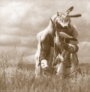


 ‘Amerinds’(or American Indians) settled in Alaska and northwestern Canada. Eventually they migrated south following the forming of an "ice-free corridor" that allowed them to move through Alberta and Saskatchewan. In time, this route disappeared when the two great ice sheets merged around 20,000 - 15,000 BC.


 3. Nishawi palliton, nishawi machiton, nishawi matta lungundowin.
  4. Mattapewi wiki nihanlowit mekwazoan.
  5. Maskanako fishy penauwelendamep lennowak owini palliton.
  6. Nakowa petonep, amangam petonep, akopehella petonep.
  7. Pekelan pehella, pohoka pohoka, eshohok eshohok, palliton palliton.
  8. Telepath miniport Nanaboush maskaboush owinimokom linnwimokom
  9. Gishikin-pommixin tulagis- hatten-lohxin.
  10. Owini linowi wemoltin, Pehella gahnite pommixin, Nahiwi tatalli tulapin.
  11. Amanganek makdopannek alendyuwek metzipannek.
  12. Manito-dasin mokol-wichemap, Palpal payat payat wemichemap.
  13. Nanaboush Nanaboush wemimokom, Winimokom linnimokom tulamokom.
 14. Linapi-ma tulapi-ma tulape- wi tapitawi.
  15. Wishanem tulpewi pataman tulpewi poniton wuliton.
  16. Kshipehelen penkwihilen, Kwamipokho sitwalikho, Maskan wagons pillowed palliwi.